Tag: weather

  • Tumultuous Sky

    Tumultuous Sky

    Storm photograph of a sunset thunderstorm over Manahawkin Bay with lightning bolt.
    Tumultuous Sky — 35mm | f/5.6 | ISO 100 | EXP 25 sec

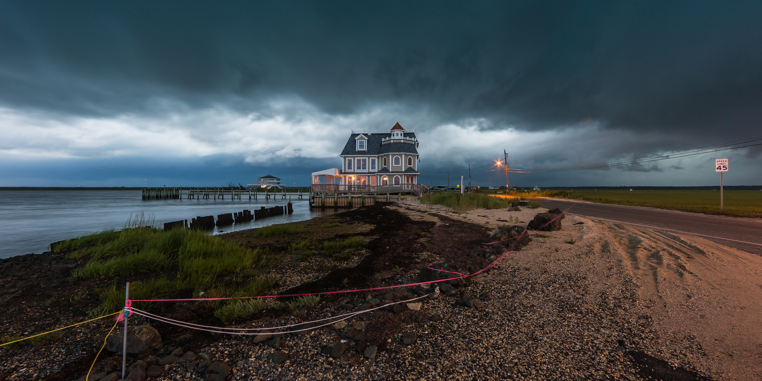
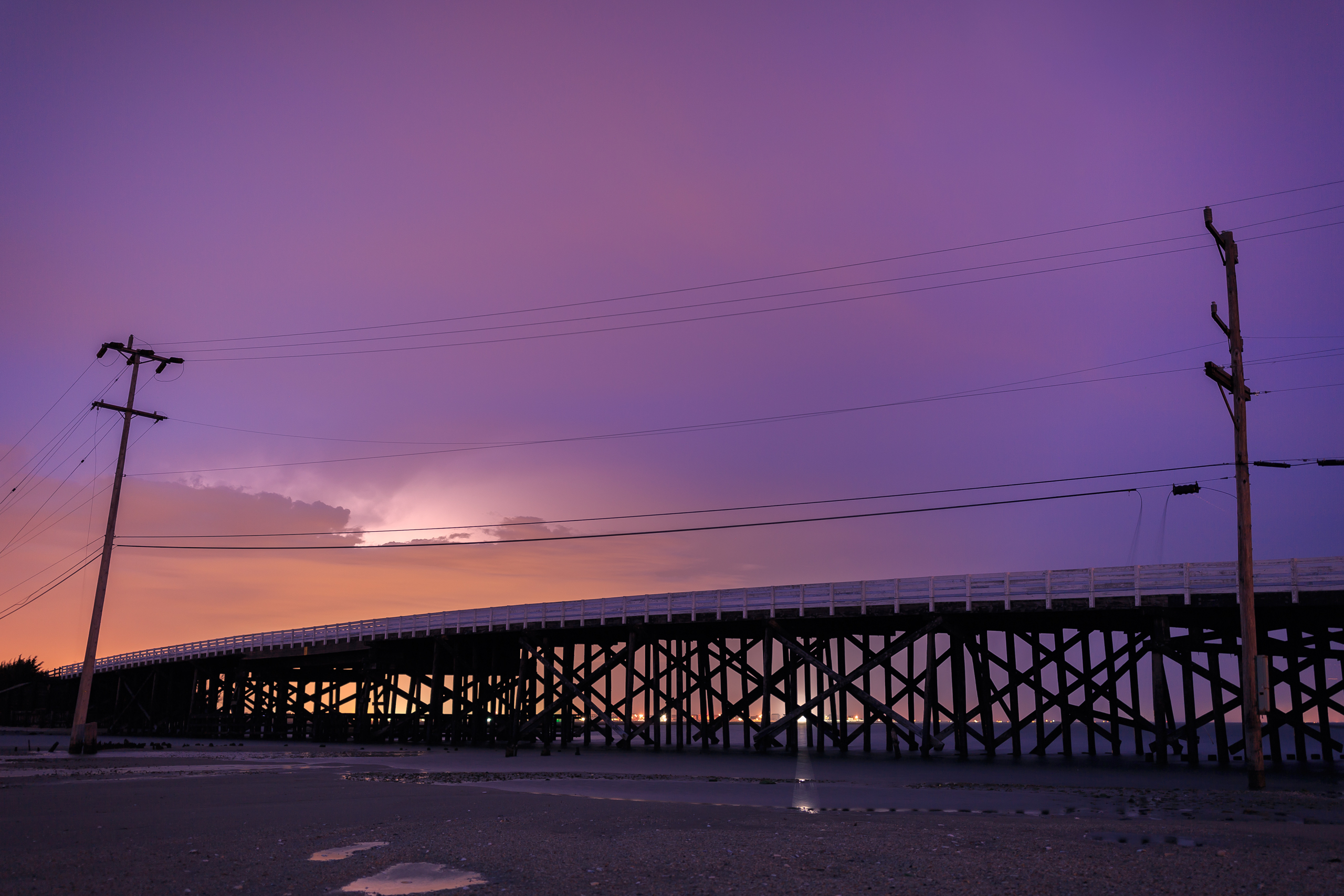
    Saturday, August 6, 2016, the unexpected came to pass. Mrs. and Mr. Weather NJ came by to scoop me for a little weekend dinner action on Long Beach Island. We brought along the camera equipment just in case the sunset would pop. We were cutting it close on time and originally decided that Cedar Run Dock Road would be our best photo destination considering the time crunch. Instead—and in true Jon Carr fashion—the turn for Route 9 South was completely missed and with it so too was Dock Road. Insert audible. With what appeared to be a cloud out at our back we made for Surf City Sunset Park. Crossing the new Manahawkin Bay Bridge my expectations were low.

    Upon arrival at the park the place was loaded with revelers and cellphone cameras. I always feel good when I see folks out taking in the sights and taking their shot at landscape photography. The more the merrier, I say. To the south a crescent moon could be seen, while to the west a mean shelf cloud was barreling eastward. We had known a line of storms was heading to the area, but honestly the radar was not all that impressive. Are you noticing a theme of underselling the evening yet? Eager to capture the shelfie, I took out the camera and swapped my 100mm lens for the ultra wide 14mm. It seemed like the prudent move except the humidity had a better idea. Instant fog problems—my lens was immediately coated in moisture. That quickly put the kibosh on my shooting—or so I thought.

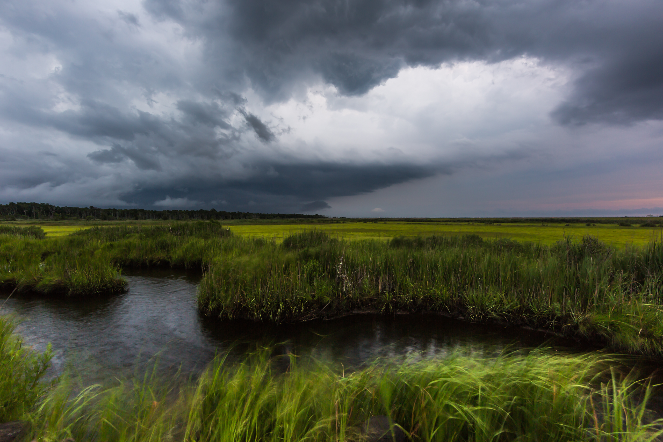
    As the clocked ticked away the initial line of thunderstorms moved through. Aside from a solid gust front and some dramatic clouds, it didn’t produce any lightning or rainfall at our location. Just a few bolts of lightning to the north. A few minutes later things started to get interesting. About 30 miles to our west, over Hammonton, New Jersey, a storm cell began to redevelop. Radar proof need not apply as its growth was betrayed by a towering cumulonimbus cloud growing before our eyes. Like something off the set of Ghostbusters this monolith of water vapor and energy grew larger and closer. Its cloud tops reaching high enough to begin sheering off into an anvil. It was awesome. The gust front, it seems, provided just enough of a trigger to ignite the latent storm growth. As a shooter this presented the perfect opportunity: an isolated cell from the perfect vantage point with no rain to mess up the shot. Also, by now enough time had passed to free my lenses from their foggy prison. I was back in the game.

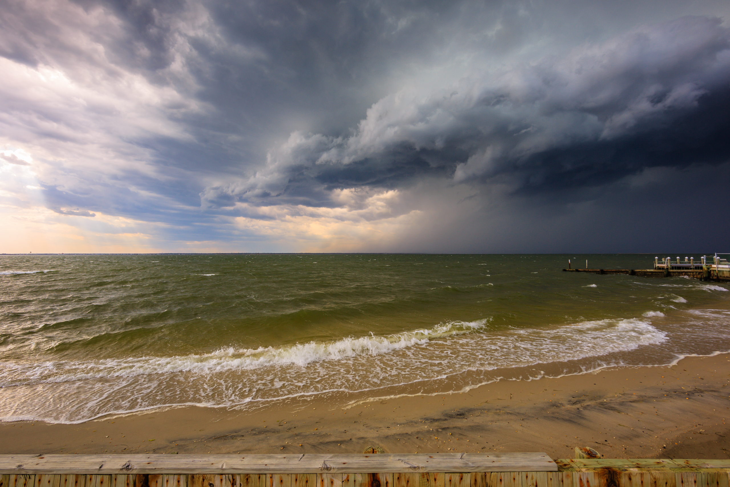
    From there on it was all about finding the optimal frame to capture the Manahawkin Bay Bridge; the impressive cumulonimbus tower; and the pastel glow that reignited at dusk thanks to the angle afford by the high cloud tops. It was the perfect storm—from no expectations came the best storm setup I have encountered to date. From there on out I put my 35mm lens to work, making long exposure after long exposure, hoping to time up a shot just right with a lightning strike. Fortunately I got some cloud to ground action mixed in with a truly dramatic sky. I couldn’t be happier with how things panned out. I now have in my possession my best storm photograph to date.

    Oh, and as for food—an LBI dinner never happened. That, too, was an audible to Element on account of large crowds. Sometimes you just have to go with the flow.

    Interested in buying? Purchase

  • They Came From Behind

    They Came From Behind

    Photograph capture of fierce clouds and thunderstorms approaching Antoinetta's restaurant from the west.
    They Came From Behind — 14mm | f/8 | ISO 100 | EXP 2.5 sec

    Gold Five to Red leader, lost Tiree, lost Dutch.
    I copy, Gold Leader.
    They came from… behind!

    Now that the titular Star Wars reference is out of the way, I’d like to throw it back to last Monday, July 25, 2016, when some serious thunderstorms had us dead to rights in southern Ocean County. After making my first capture on the western most end of  Cedar Run Dock Road (where the marsh opens up from the woods), Jon and I made our way to the east most point of the marsh. Posted up at the boat ramp, we aimed our lenses westward toward Antoinetta’s restaurant and dug in to watch the rapidly approaching storms. Meanwhile in my head a story was set in motion: eager diners going about the machinations of a pleasant dining experience full of fine meals and good conversation before some astute weather observer inside took a westward glance out the many windows to notice the beast barreling in from the west. At which point all attention would divert from the chicken parmesan and risotto to impending doom. One customer would lament a power outage while in the same breath some haughty sir insistent on keeping his head firmly entrenched in the sand would bombastically declare ‘there’s no way that’s going to hit us!’ It is, after all, your world and we’re just living in it.

    Interested in buying? Purchase

  • Weather Moves

    Weather Moves

    Wide angle photograph of severe weather clouds moving in over a salt marsh.
    Weather Moves — 14mm | f/8 | ISO 100 | EXP 1/4

    Monday, July 25, 2016, saw severe thunderstorms batter much of the mid-Atlantic; the early morning hours featured the first round, a natural alarm clock potent in its own right, only to be outdone by the main event during the afternoon and evening hours. The widespread storm outbreak managed to hold together all the way to the New Jersey coast. The perfect storm of high CAPE values, substantial sheer, diurnal heating, and sky high dew points and temperatures fostered a caustic atmosphere for powerful storm development and continuation of the line for hundreds of miles.

    Out on Cedar Run Dock Road, Weather NJ’s JC and I did our best to document the essence of the storm. While I didn’t pull down any good lightning shots—they continue to elude me—I did manage to make a few photographs that convey the anger and intensity of the sky and the subsequent winds that came with it. Even in the shot above, which was made a good 15 minutes before the severe warned storm hit, you get a sense for the ferocious nature of the ever changing cloud deck. Converging air masses were seemingly ripping the sky apart. The marsh betrays the wind intensity that would be otherwise invisible to a photograph. Even at a 1/4 second shutter speed, you can clearly see the foreground marsh grass folding like a tent. At this point I would guess winds were in the 30 MPH range. (With peak storm nearly doubling that speed.)

    On a personal level the pressure of the moment becomes a lot to deal with. You know you’re under the gun. You know strong winds and high voltage is fast approaching. You know wind driven rain will soon be upon you rendering a camera effectively useless thanks to soaked lenses. Rolling thunder in the distance coupled with lightning strikes on the horizon gets the heart rate up, and it’s a real struggle against nature and your best instinct to remain calm and patient enough to make good shots. It’s a far cry from the relaxed pace of a predictable, slow moving sunset that’s for sure. Of course, it’s this adrenaline surge that’s a big part of the fun.

    In the meantime I have one or two other photos to post from Monday, and JC went live on the Weather NJ Facebook page and produced the following video (approximately 36,000 views at the time of this posting!) documenting deteriorating conditions peak storm. Check it out.

    Interested in buying? Purchase

  • The Home Fire Still Burns

    The Home Fire Still Burns

    Sunset photograph of dramatic clouds painted in fiery pastels left behind after storms rolled through Long Beach Island.
    The Home Fire Still Burns — 14mm | f/8 | ISO 100 | EXP 1/5

    Sunday began what is now day four in a stretch featuring potent storms, dramatic clouds, and fiery sunsets. While I’ve been tied down and largely unable to shoot, it’s been impossible to miss what has to be the best consecutive stretch of sky goodness in recent memory. New Jersey based social media accounts have been set afire with countless jaw-dropping photographs for the better part of a week. Thanks to ubiquitous smartphone adoption the degree of documentation has sailed far beyond unprecedented levels. Everyone is a photographer now, and I think it’s is great. Scrolling through my Instagram feed this week has been a total treat.

    Above is my small contribution for the week. This photograph was made at Surf City Sunset Park on Sunday evening. Strong to severe storms were powering across the mid-Atlantic, bringing strong winds and heavy rainfall. Unfortunately the line fizzled just as it made its way to the coast. While a proper shelf cloud never materialized over Barnegat Bay, it was becoming readily apparent the clearing would time up perfectly with sunset. My friends and I bailed from our Barnegat Light thunderstorm position and made our way south into Surf City. From there it all came together. To the east was a properly majestic double rainbow backlit by a stunning array of pink storm clouds. To the west, a potent sunset stretched across the sky. So powerful was the light differential from sun to storm clouds that auto white balance was rendered effectively useless; leaving RAW files cast in a strong purple hue if left untouched. When this extreme is achieved you know you are in the presence of some properly dramatic light play. For me, I was simply dumbfounded; left holding my gear, smiling ear to ear.

    Interested in buying? Purchase

  • All Too Familiar

    All Too Familiar

    Wide angle landscape photograph of ominous storm clouds rolling over a lush green salt marsh
    All Too Familiar — 14mm | f/8 | ISO 100 | EXP 1/80

    Hey, New Jersey! Maybe you’ve noticed it’s been raining? Or maybe you live under a rock? In which case you’ve more than likely been claimed by the Drowned God. It’s been over a week now and it seems to be the only weather we know. This photo is actually a throwback to April 26 when a pattern flipping cold front powered through the mid-Atlantic bringing strong storms and powerful straight line winds to the region. Since that day it seems we’ve been in omega block city—only we’ve been on the wrong side of said block. The cold, wet, raw side. Not exactly the pattern anyone wants in late-April, early-May. Unless of course a sea of endless grey is your thing. While it looks as though a few breaks in the clouds may appear over the next couple days, it seems we’re heading right back into the soup for much of next week. To modify the cliché, April flowers bring grey skies to May that never end. Welcome to Ireland, New Jersey.

    Heh, fittingly enough Jerry Garcia & David Grisman’s “Dreadful Wind And Rainjust randomly queued up on my iTunes as I finished paragraph one. If I could go back and do it all over again, I think that’s what I should have titled this shot. Alas, hooray for a fitting coincidence. Now where is that blasted Sun?

    Interested in buying? Purchase

  • Disrupt

    Disrupt

    Wide angle photograph of an ominous shelf cloud storming over Barnegat Bay en route to Long Beach Island
    Disrupt — 14mm | f/8 | ISO 100 | EXP 1/125

    Wild weather bore down on Surf City’s Sunset Park yesterday afternoon. I was fortunate enough to be out storm chasing with JC of Weather NJ fame, and we set up shop on a favorite Long Beach Island bay beach. With a dead west exposure over Barnegat Bay, winds were already ripping from the same direction, and a well defined shelf cloud was easily seen contrasted by the dark brooding cloud shadows behind it. Most striking, however, was the eerie green hue that illuminated the roiling bay water. It was an unnatural savage green, amped by full afternoon sun pouring in unfiltered from the south that was magnified as it bounced off the cumulonimbus cloud bottom. This, in effect, created lighting conditions that would be something akin to millions of pool table lights draped only feet over the bay. It was one heck of a sight. I’m sure my Snapchat followers could hear my excitement. (Not to mention a few expletives born of exuberance.)

    No less than two minutes after popping off the photo above, the gust front made landfall, temperatures dropped 20 degrees within 10 seconds (no exaggeration), and the winds went from about 35 mph sustained to ~60 mph. Severe storm criteria is defined as 58 mph winds or greater, and we were certainly there. Of course, the lion’s share of thunder and lightning slipped just to our north, but man it was fun being out there. Talk about a charge of energy. Here’s a short film JC shot to give you a sense of the sandblasting wind. (That’s me standing out there trying to capture cellphone footage.)

    Interested in buying? Purchase

  • Such is Life

    Such is Life

    Macro photograph of a dead Jane Magnolia blossom
    Such is Life — 100mm | f/3.5 | ISO 100 | EXP 1/250

    Unwelcome cold has crashed the Mid-Atlantic early spring party and brought its unsociable below freezing friends with it. After a well above average March, with temperatures readily exceeding the 70s and 80s, winter has stormed back with a vengeance laying waste to my Jane Magnolia bush. It was only a week ago I wrote about how pumped I was to finally have my Magnolia back in full bloom after years in absentia. But after a week of morning lows in the 20s here we are back in the tundra with dead flowers in its wake. So much for getting my hopes up—thinking I’d make bunch of macro photos of its lovely purple blossoms this year. At this point I am just hoping today’s rain, sleet, and snow is it for winter 2016. Let’s get on to spring. Again.

    Interested in buying? Purchase

  • Land Bridge

    Land Bridge

    Long exposure photograph of Great Bay Boulevard's first bridge backlit by lightning.
    Land Bridge — 35mm | f/1.4 | ISO 100 | EXP 20 sec

    Friday evening I hitched a ride with Jon Carr and we made our way to Great Bay Boulevard. The hope was twofold: 1) outside shot at a well timed break in the clouds for sunset ignition; and 2) with a segment of thunderstorms approaching from the west, lightning captures were on the table. While neither outcome panned out in the ideal the night wasn’t a total wash. Under the gun of days of stiff west by northwest winds, a blowout tide exposed a land bridge and thereby allowed me to shoot from a sand plain that’s far more often than not under the cover of brackish water. Advantage: Greg. This afforded me a rare angle on Great Bay Boulevard’s first bridge, and I did my best to exploit the opportunity.

    Surely I wanted some high drama cloud to ground lightning from this vantage point, but considering we were about 20 miles south of the real action that simply wasn’t in the cards. Instead I tried to make the most of the cloud level flashes coupled with the low cloud deck that was bouncing the light pollution in a cool array of orange, pink, and purple hues. One of the reasons I added a 35mm lens to my bag was for some better lightning photography. More often than not the 14mm is just too wide, and unless you have the fortitude to let the lightning get right over your head the bolts are oft too far in the distance. My hope is the 35mm while bring in the right amount of intimacy while remaining wide enough to still capture a good piece of the sky.

    Interested in buying? Purchase

  • Spring Too Soon

    Spring Too Soon

    Square format photograph of a freshly bloomed daffodil
    Spring Too Soon — 35mm | f/2 | ISO 100 | EXP 1/5000

    Eager for some more lens time, I photographed this daffodil earlier today. Chilling on the north side of my yard, it’s always my first flower to bloom—a clockwork messenger chiming to the first sounds of spring. A spring it seemed that was on with a vengeance this March. Seeing temperatures readily cracking 60, with several spikes into the 70s and 80s. Record shattering warmth after the back-to-back, bitterly cold backloaded winters of 2014 and 2015 that locked the mid-Atlantic in ice. Finally it seemed this was the year to rocket off into an early, and perhaps even warm spring.

    [Insert cliché record scratch] We toss.

    In spite of our best hopes of a Cinderella springtime, it’s looking more and more likely that the region will face a significant late season storm Sunday into Monday. Just in time for the start of spring. The spring that once held such hope. Instead we may be looking at widespread moderate to significant accumulations across the area. So all those poor cherry blossoms that got dressed up early this year will have their nascent blossoms held in icy cold hands. I guess we hold our collective breath that the moderate temperatures spring back post haste.

    As far as the photo goes, here’s shot number two with 35mm. I’ve been keen to see how the bokeh would show with flora work, and the daffodil’s spring showing made for a timely subject. With plenty of mid-day sun pouring down, I rifled off a few shots from an approximate distance of about 10 inches from the daffodil bloom you see above. Stopped down to f/2 there’s plenty of buttery bokeh smoothing out the shallow depth of field. I love this kind of shooting—thin areas of selective focus that make for a more airy, whimsical feel.

    My brief time with the new lens continues to impress, even if it still feels a bit foreign to me. From today’s quick session the takeaway was all about color. Specifically the color rendering in full, harsh sun. The blues and yellows being particularly vivid standouts.

    Interested in buying? Purchase