The Cold Will Roll — 14mm | f/8 | ISO 100 | EXP 1/125
It’s on, New Jersey. True arctic air is rolling across the Northeast and Mid-Atlantic and with it comes a polar left hook of cold to the jaw of we the lower latitude dwellers. While the bays remain open water for now, the marshes have begun the inescapable transition to pop-up ice world. In the face of possible subzero temperatures overnight I imagine said bays will not be far behind. This is a not so welcome reminder of the powerful cold we squared off against in winter’s 2014 and 2015. Fortunately this cold snap will not have that kind of staying power.
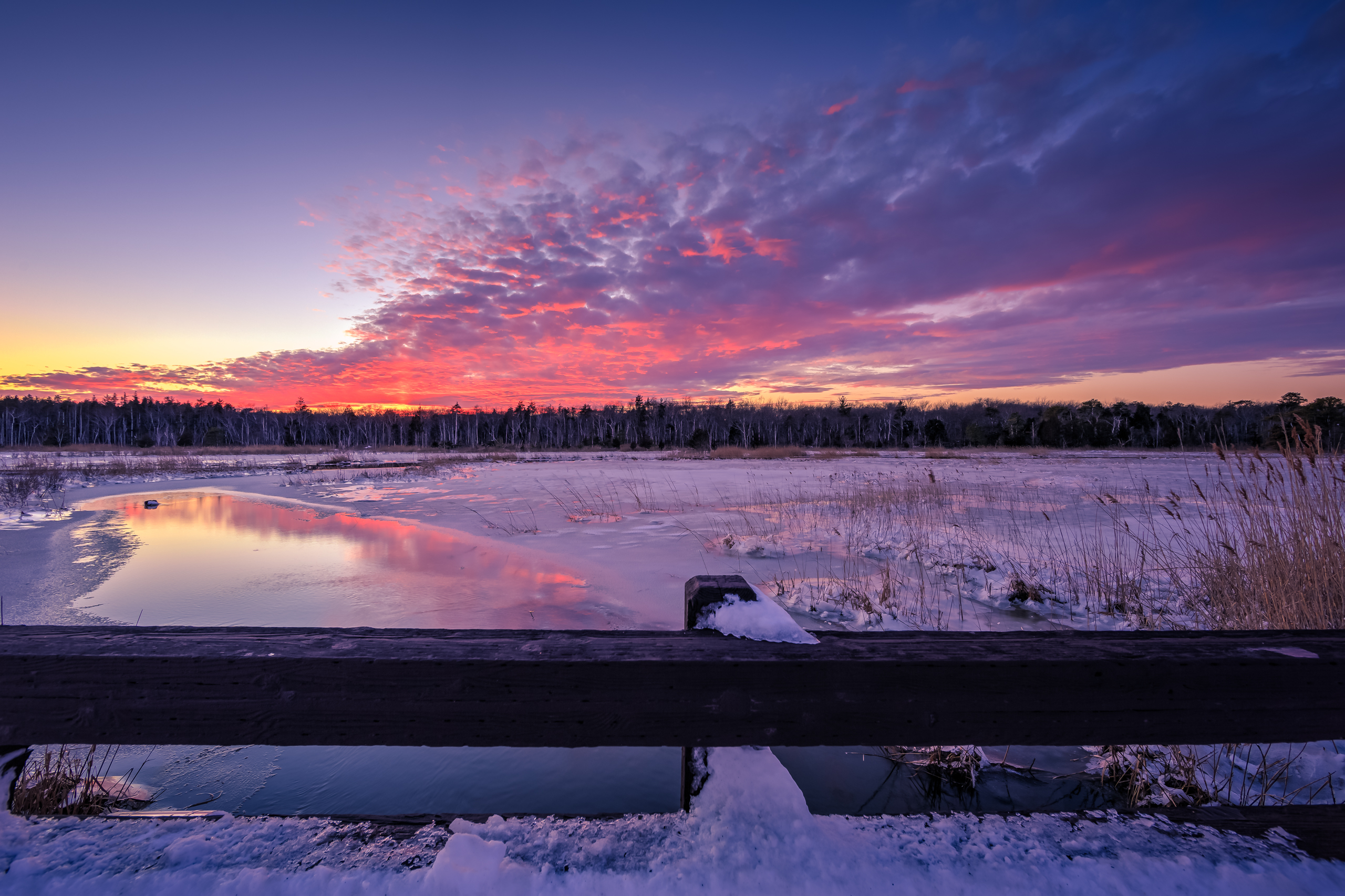
In the face of biting cold and stiff wind I simplified my shooting workflow tonight. There was no tripod. There was no bracketing. With steady gusts over 30 mph, stability and warmth was a factor. With that I had a go with some old school single bracket handheld shooting. Aided by a frozen marsh I was able to get up close and personal with the tide pool above. On my knees from right at the water’s edge, bringing the viewer right into the sunset action. Juxtapose this with a very similar shot I made earlier this month from this spot where I am set farther back, with the camera several feet higher. Notice how the perspective and intimacy change over the span of only a few feet? I prefer tonight’s tucked in look.
From now through Sunday we let the cold air roll. May it bring the deep purple sky I long for.
The winds of change blew through the coastal Mid-Atlantic region turning 60 degree temperatures and rain on Thursday into a fleeting winter wonderland come Friday. The predawn hours saw a changeover to snow from west to east as an over-performing coastal low pressure developed along a stalled cold front just off the coast. While there were hints of this possible outcome, a mid-week fade from the models coupled with unseasonably warm temperatures sent this system to the farthest reaches of public consciousness. A trend to a northwest solution began in earnest on Wednesday and didn’t look back until widespread 3″–6″ fell upon an unsuspecting region. As as the alarms sounded many questioned whether 60 degrees and soaking wet ground could create an accumulating snow solution some 18 hours later? In hindsight such skepticism was put to bed.
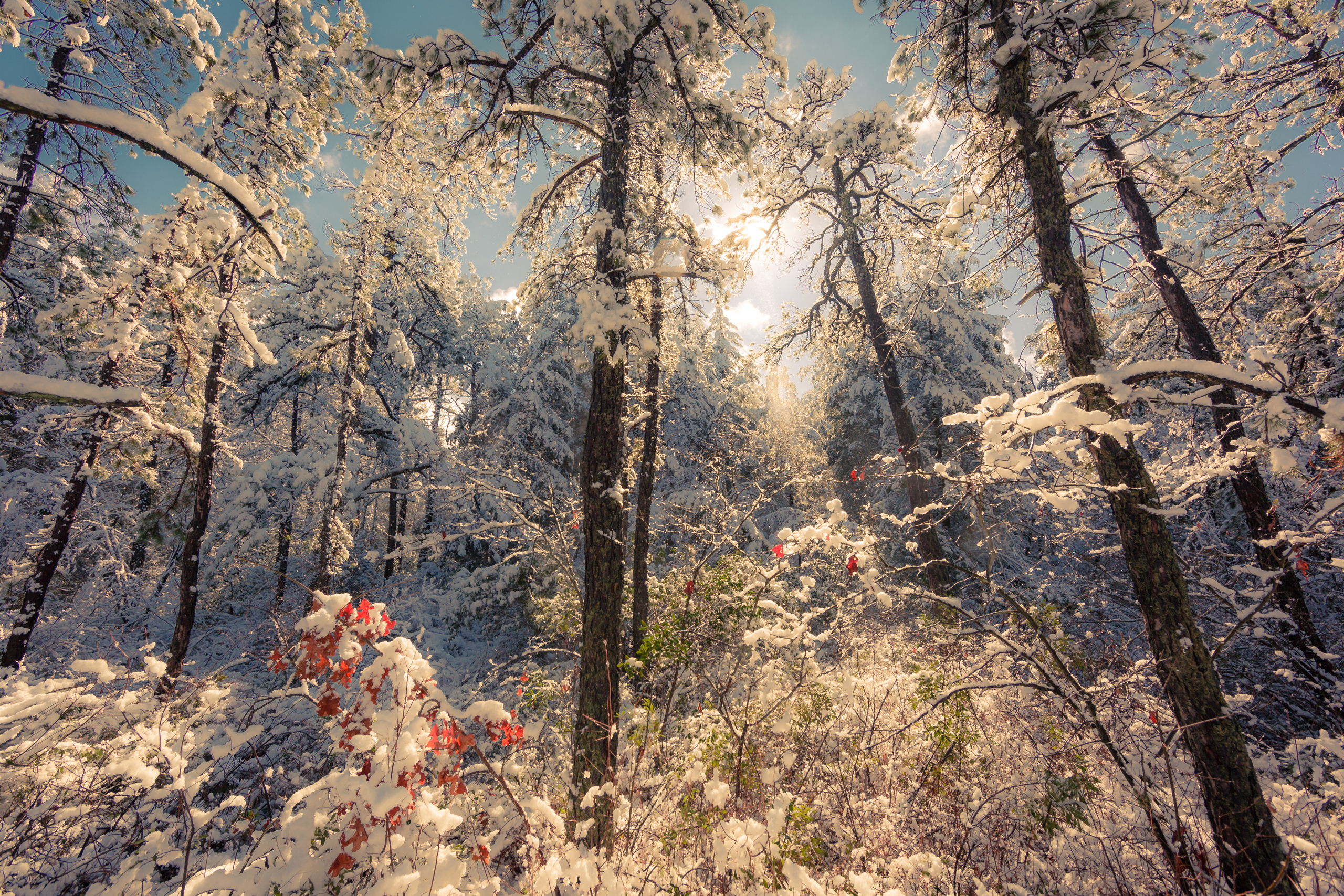
For my entire life I’ve watched the weather in awe. Captivated not just by its patterns and trends, but by its consistent penchant to surprise. There are no sure things in weather, and given a large enough sample size over a long enough period of time, and you’re bound to observe rare, if not entirely unique occurrences. In this case not only did the snow show up with much surprise and in the face of doubt, it also disappeared nearly as fast as it came. While making photos out in the Greenwood Forest Wildlife Management Area just after the snow had stopped the great thaw had begun immediately. A snow melt the likes of which I had never seen. With sun-kissed energy pine boughs began shedding their load as temperatures rose and some wind worked through to ease their weighted burden. Steady streams of snow, water, and ice were melting away at a rate I’ve never before witnessed. It was as if the Pinelands were insistent upon forging forward to spring in the blink of an eye. Despite clear skies working in, the forest looked and sounded as though a robust summer downpour was working through the thicket. You could watch and hear the earth take its snow back in real time. A symphony for the senses.
Of course the immediacy of the melt brought on some needed expediency for making photographs. Matters were made a bit more tricky as softball sized snowballs were dive bombing the ground both readily and at random from the canopy. My camera and I took a few good hits before the lens and body were too overwhelmed with water, giving me just enough time to make this photograph and a few others. A brief moment in time captured before any remnant of our latest weather event fell into obscurity. A ghost storm if there ever was one.
Oh, and there are a few storm signals looming to start next week. For now, we track.
A Bridge Too Far — 14mm | f/8 | ISO 100 | 7 Bracketed Exposures
There would be weather they said. Follow the global models they said. Disregard the NAM they said. The heaviest bands will never push north they said. Well here we are one day after the Blizzard of 2016, and I’m sure many a backs are barking from a long day of digging out after wondering, dude, where’s my car? This was one for the record books, folks, and even though the biggest snows happened just a few miles to my north and to my west, the coast sure saw a battering at the hands of a fired up Atlantic Ocean. After spending the better of the weekend weathering the storm with friends, fretting over rain/snow lines only to later find myself and swan diving into snow after the changeover, my buddy and I finally made it out for some real deal photo making this evening.
After much hemming and hawing over where to shoot, most of which happened during a pitiful attempt to clear out my driveway, an unsolicited query from family friends on Dock Road asking my Mother if I was out shooting said road solidified the final destination. Understanding the marsh isthmus no doubt took a serious tidal beating, we didn’t exactly know what we were in for at the Road of Dock.
The scene upon arrival was otherworldly. Elevated sea levels and ice flows littering the marsh dominated the landscape. While the tide was mostly down at this point, its frozen remnants were not hard to parse out. The vestiges of a foul tempered nor’easter were visible horizon to horizon, and before long the power of the wind was clearly on display. No less than four telephone poles were down, with power lines sidewinding the single road for what must have been a mile. Yes the scene was surreal but that was quickly supplanted with the sobering reality that real humans live amidst this battered place of wonderment, and here they are tasked with wintering it out sans power in the wake of a powerful winter storm—one that will most certainly be regaled as historic in the pantheon of east coast storms.
While my picture making was at a minimum this weekend, yet this photograph marks my first documentation of New Jersey in a post Winter Storm Jonas world. Here’s hoping you fared as well as possible during this powerful weather system, and were able to make the most of your time indoors. Cheers.
Perhaps this is Goodbye? — 14mm | f/8 | ISO 100 | 7 Bracketed Exposures
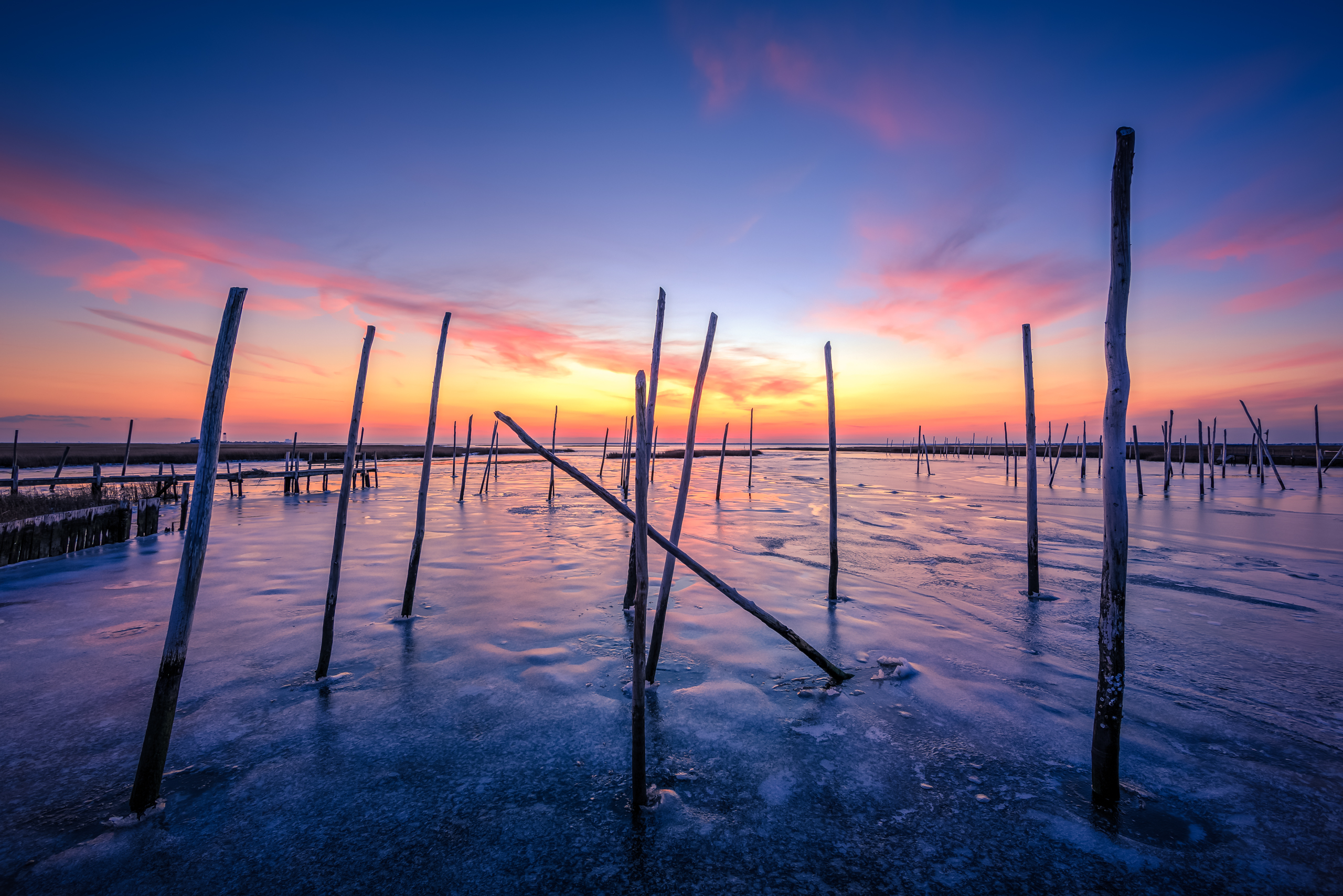
Be it superstition, confirmation bias, or an actual demonstrable trend to which I have neither the data nor scientific awareness to prove, pre-storm sunset skies always seem to deliver. Today sure fit the narrative. Anticipating winter storm Jonas’ arrival has ground my personal perception of time to a relative halt. Since Monday night the hours, such as they are, have ticked by like days as I click weary-eyed from one model run to another, waiting interminably on weather to arrive. Yet no matter what the models show me, and despite the Blizzard Watch we’re sitting under currently, the pangs of last year’s bust at the hands of Juno gnaw away at my insides. I just want the snow to get here, stay here, and with any, luck bring little to no rain to southeastern New Jersey. Of course that toasty Atlantic Ocean looms large, ready to push warm maritime air onto our shores if the center of low pressure creeps close enough.
But let’s push my selfishness aside for a second, coastal flooding and beach erosion is the real concern here. But as the far less sexy story overshadowed by the high probability of widespread 12″ snow across much of the Mid-Atlantic, the tidal implications of a roiling ocean have been lost in the shuffle. We’re looking at an extended storm with a duration over 24 hours complete with a broad wind field of tightly packed isobars slinging wind gusts of around 60mph onto New Jersey shores. It’s subsequent storm surge will be aided by an ill-timed Full Moon giving an unneeded boost to already moderate to major tide heights. At least three high tides will be affected from Saturday morning through Sunday evening.
It is with this reality I title my post. Understanding the marina is now state owned and seemingly set to restore to its natural state, there’s a good change this little cove will look quite different as soon as Monday. These derelict posts of wood that once gave aid to docks and quays may soon be little more than a memory. This is why in considering where on Great Bay Boulevard to photograph today I recalled the wise words of Ben Wurst, instructing me to shoot here as often as possible fore it may soon be gone.
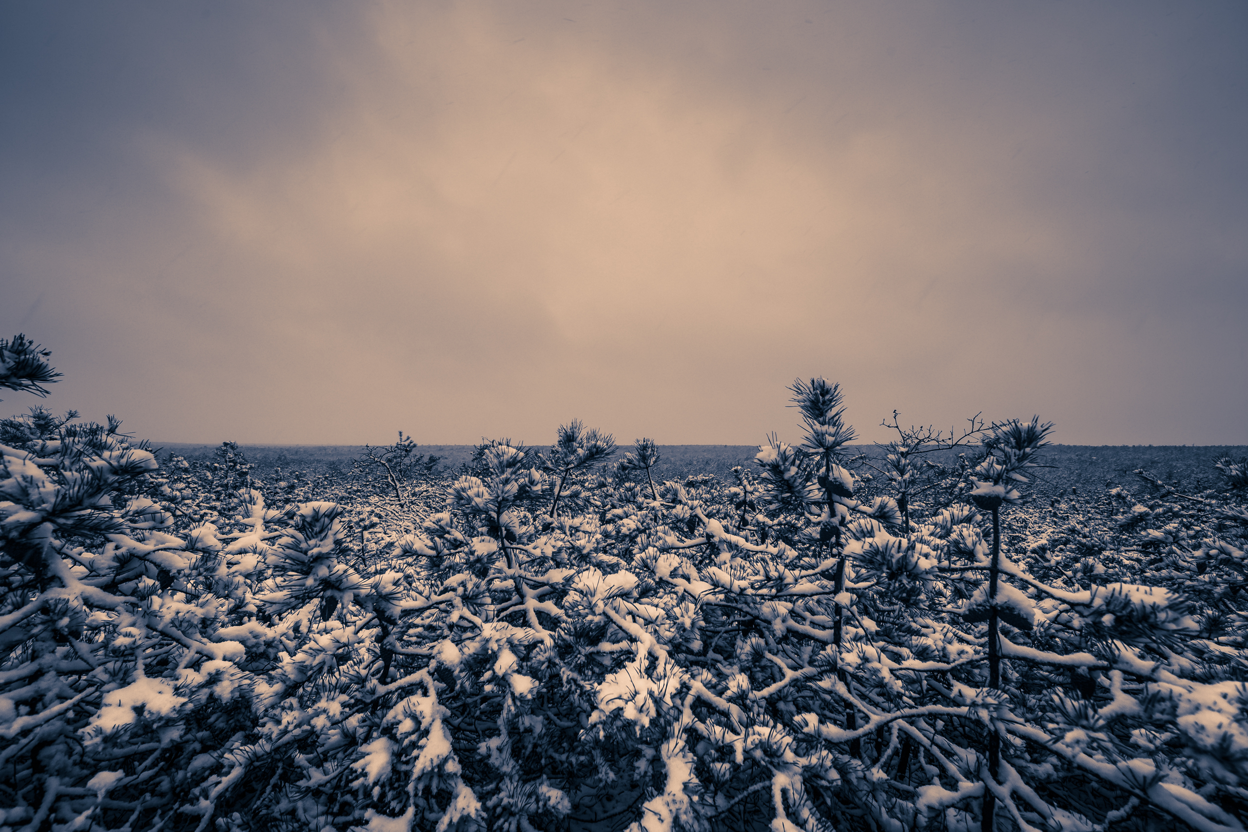
Let’s talk about the weather, Mid-Atlantic. In case you hadn’t heard there’s a potential snow storm looming, turning its tentative gaze toward the weekend. But first, proceed with caution. It’s been a tough winter for snow lovers, and we would do well to consider the unreliable performance of operational models of late. Despite a conducive pattern for coastal storm development we’ve seen one promising event after another appear, disappear, only to reemerge late in the game sending cutter after cutter into the Great Lakes. Whereas today we saw a storm widely thought to be out to sea, hang close enough to the coast to bring a mostly unexpected 1–3″ of snow to southeastern New Jersey—with an even bigger hit along the Delmarva. Were it not for marginal temperatures just above freezing this would have been a major bust. Suffice to say, faith in the models has been tested, and we should all feel justified in our skepticism. Of course there’s a lesson in here: despite improving datasets, more powerful processing, and better defined atmospheric dynamics there’s still plenty to get wrong in forecasting. We’re still a ways from perfect and that’s perfectly okay.
Tempered emotions aside, it’s tough not to get a least a wee bit excited for this weekend. Some factors driving our optimism? Consistent plotting of the storm on the major weather models for at least the past 48–72 hours; we’re now progressing well into mid-range forecasting (less than 120 hours out); and most importantly, the pattern at 500mb looks favorable. Tonight’s 00z runs will be huge, and weenies (a term for weather enthusiasts like me who know just enough about weather to be dangerous) will be staying up late on this Martin Luther King, Jr. weekend waiting for the Euro. While it’ll be fun to get caught up in the excitement, we should at least wait until Tuesday when this storm is properly sampled. Said sampling allows real data to be input into the model algorithms, ensuring much greater accuracy as the models will be relying on fewer unknowns/hypotheticals. By then if the trends still look good it’ll be game on and milk and bread memes will be in full effect. In the meantime, stay tuned to Weather NJ for the latest.
The Demons of Our Dreams — 14mm | f/2.8 | ISO 100 | EXP 30 sec
When I’m titling my photographs I most always go with the first word, phrase, song lyric, or bit of text that comes to mind. It’s a quick and easy approach that keeps me from overthinking my named works. I broke that rule today. I wanted to go with Death Comes for us All, but an apprehensive voice inside me chided that might come across too strong. Death’s a touchy subject, and I’m not here consciously looking to set off any triggers. Ergo I downgraded to demons.
What led to the death/demon connection in the first place? Well as I look at the 30 second long exposure rendering of this photograph, with its low hanging shelf cloud accentuated by motion blur marching across Barnegat Bay; a Titan’s visage, gaunt and brooding, manifests pressing downward through the clouds ready to escape its confines to breach the bay and do its worst. It is both spooky and spectacular—natures reminder of the omnipotence of the universe and our fleeting moments hurtling about our own speck of space.
This photo session started out as an attempt to capture a less abstract look at storm clouds, and even more specifically some lightning. Instead something wholly unexpected manifested on the sensor. That’s the way photography goes sometimes, and it’s important for us to always keep an open mind to the unintended outcomes it may render.
Having returned from vacation just yesterday I was left on the outside looking in as days of rain, wind, and tidal surge battered New Jersey beaches and intracoastal ways. Even though our area was spared the brunt of Joaquin thanks to just missing a capture from an upper level low spinning over the southeastern United States, my home town and neighboring beaches and waterways had front row seating to extended onshore flow that wrought moderate tidal flooding and a deluge of rain.
Sitting in Florida, a mere few hundred miles from the center of Joaquin’s cyclogenesis, I was crossing my fingers model run to model run as spaghetti plots meandered all over the eastern seaboard; many sending landfall to areas directly affected by Superstorm Sandy. Ultimately, after laying a beating on the Bahamas this turned into a fish storm and began its northeast march toward Bermuda and out to sea. But with a powerful blocking high pressure locked in around Maine and the low pressure of the storm off the coast of Florida, Mother Nature set up the physical mechanics of a pitching machine enabling a 72-96 hour period of onshore flow to fire streams of moisture and wind at much of the east coast; bringing devastating rain to South Carolina and beach erosion to many coastal areas. With the abrupt left hook of Sandy still fresh in all our minds, this was a little too close for comfort.
Pictured above is my photograph of tonight’s sunset still showing off the tidal remains of all that water that was pushed up toward the coast thanks to that pitching machine effect. Despite being days after peak flooding you can get a sense of just how long it takes water to recede safely back whence it came.
A Sign of the Times — 14mm | f/8 | ISO 100 | EXP 0.8 sec
I’ve been sitting on these two photos for days; sulking in my own prison, shackled by the nonsense sentencing of my own perfectionist imposition. In some kind of martyred protest for the way events unfolded this past Tuesday, June 23rd. In other words acting like a petulant child.
I’ll spare the minutia but Tuesday started off all sorts of wrong thanks to an internet connectivity outage that interrupted much of coastal New Jersey for the better part of a day. A nightmare for Facebookers everywhere. This laid waste to my plans and sent me into the office on a day I was prepared to work from home. Just as importantly on a day I was prepared to shoot. Was prepared being the operative words here. You see, the best thunderstorm threat of 2015 thus far was becoming quite likely 24 hours out, and that the weather event would coincide with the golden and twilight hours. All the ingredients, man.
Connectivity issues be damned I put on my big boy pants, packed my things, and went to work. Accepting fate through self-deprecating laughter it was at this time I struck storm chasing from the day’s to-do’s and instead shifted focus to my deliverables. Yadda, yadda, yadda a day’s work and hit fast forward to leaving the office: the line of storms was about 30 miles to my south and west, moving due east at roughly 45 MPH. Could it be true? A chance for a well-timed rendezvous? Based on RadarScope positioning, I estimated the clock would afford enough time to get to my house to grab my gear. Everything looked great until I hit the light at County Road 539 and NJ-70 (~23minutes from my house); the already impressive line was expanding from the middle out into a bonafide bow segment driving across Salem, Gloucester, Burlington, and into Ocean and Atlantic Counties at an accelerated rate. By the time I made it to NJ-72 and turned eastward, the veil of black dominating my rearview said it all: getting to Dock Road for photos in time for the storm was simply out of the question. At this point it was simply get home, Greg.
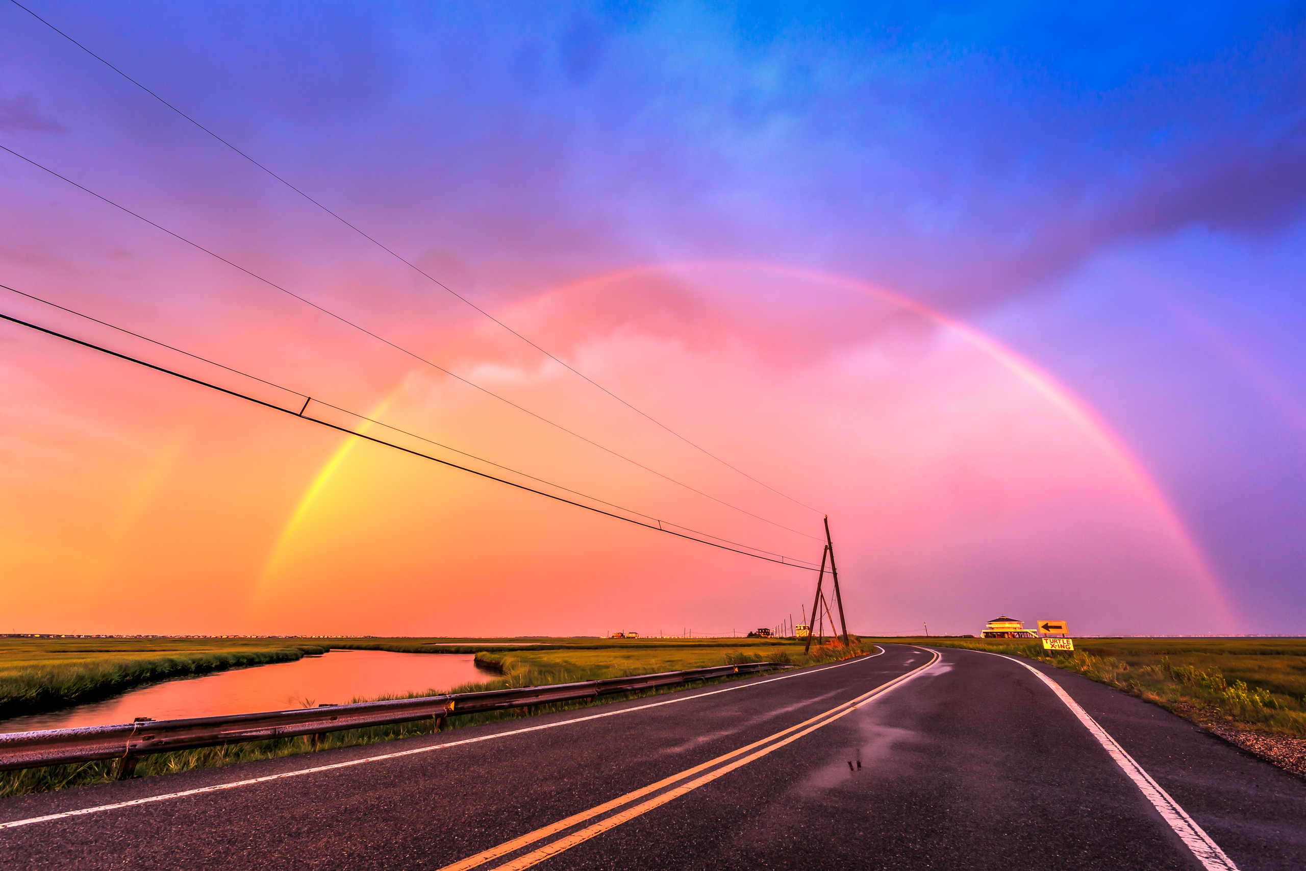
Insert a rain, wind, and light show and you have what was a 15 minute raucous ride out at my house. Immediately afterwards text from friends and look to the west let me in on a little secret: the sun was going to get under these impressive cloud formations and roving lightning strikes just in time for sunset. Everything was in play—lightning, rainbows, a palette of intense color, dogs and cats living together? Without a second thought I loaded the car and made for Dock Road.
Posted up at my usual spot the scene was something. Storm clouds rolling, strong wind shipping, thunder clapping mere seconds after spokes of lightning splayed across the sky, pouring rain, and one rapidly developing sunset. Car bound thanks to rain and lightning I was missing out. If I could have kept my lenses dry I would have said to hell with the lightning and risked it, but the rain was too strong to get more than one clear shot off at any one time. At this point I was lamenting (re: complaining) to Twitter that I was 5 miles too far to the south. A few minutes into my pity party the rapidly intensifying light at my back (to the west) mixed with falling rain put me on instant rainbow alert. Seconds later there it was: bold and beautiful straddling Dock Road in full double rainbow regalia. Thunder was booming, lightning was cracking, the sun was shining, and this rainbow was saying hey, what’s up armchair photographer man? It was glorious.
It was then my mind downshifted into the hell with everything mode. I grabbed my tripod and set it up in the middle of a kaleidoscopic Dock Road. I fixed my camera, pressed the shutter, and proceeded to make a huge mistake. After the first shutter press I realized I didn’t have my two second timer enabled—I always use this to prevent any camera shake as the shutter is depressed and the mirror flips. Except this time it screwed me. Royally. I quickly enabled the timer, pressed said shutter, and immediately witnessed one very bad ass lightning strike sprawl throughout the sky, originating from dead smack in the middle of the rainbow. As the two second wait for eternity was up, the lightning was gone and the picture was taken. With nothing but the rainbow you see above. I blew my chance. I made a mistake and it was all www.nooooooooooooooo.com from there. Three and a half years into photography and I fold like a tent in the midst the best lighting/environment/sky conditions I’ve yet to encounter. Maybe next time I won’t choke so hard. Whenever that is.
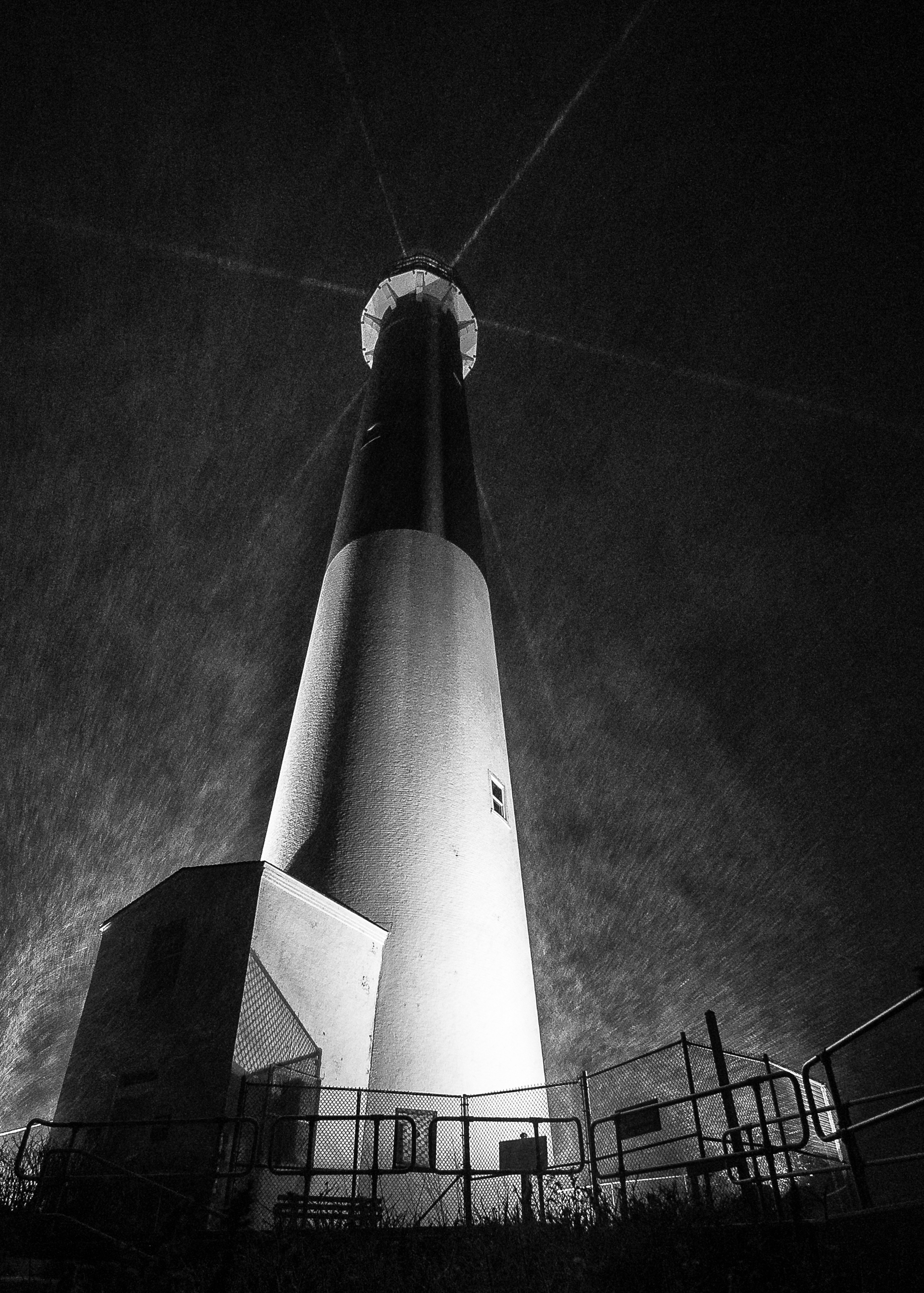
Taken a the top of the 10 o’clock hour, I tucked in low and close along the concrete seawall that runs all the way out into the inlet. With the wind at my back and cover to my right flank, I was able to affix camera to tripod and rifle off a few shots before the combination of intense snowfall and wind compromised the clarity of my lens. Wanting to capture snow flakes and the lighthouse beams in the shot I had to dial my aperture wide open and crank the ISO to 5000. This afforded me a 1⁄30 exposure—fast enough to freeze the scene.
Distracted by storm and snowfall I arrived home and ignored the contents of my memory card. It’s only today, Wednesday, that I’ve gotten to really see this shot for all its worth. Black and white processing was the obvious choice from the get go, with the white of the lighthouse lending strong contrast against the backdrop of a roaring night sky. The Lighthouse itself bears the brunt, revealing an icy spine running vertically down the whole of the structure just to the right of center—its unwavering position a testament to the steady, yet unrelenting direction of the fierce wind howling out of the north-northeast.
When you’re out there exposed to the elements as nothing more than a vulnerable sack of human, you really appreciate both the intensity of weather and the fortitude of man. Here stands a singular column, standing sentry, strong as ever.